Actually you can cover ground faster than an aerial archaeologist but with more image resolution limitations.
What you look for generally are different kinds of "marks" known as crop marks, soil marks and shadow marks.
Crop marks: Former human activity often effects the growth of crops on the surface above the buried sites. For example, crops or vegetation grown over an old buried ditch tend to grow higher, while crops grown over a stone wall or structure will have stunted growth.
Soil marks: Soil marks occur usually when one moves one kind of soil from one location to another as when building dikes or mounds. Often the soil is of different color. Sometimes the soil becomes stained as in the case when old wooden structures have decomposed leaving marks that are sometimes discernible.
Shadow marks: These are marks caused when old structures cause uneven elevation on the ground's surface above. During certain times of the day when the Sun's angle is right, the ridges, mounds, etc. can be detected from above by the shadows they cast.

From: GIS and Remote Sensing for Archaeology

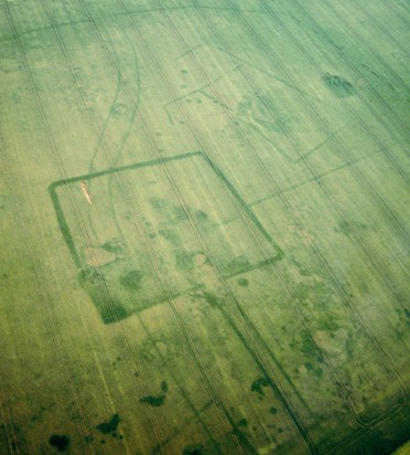
From: Prospection aérienne en Étampois. Crop marks.
Aerial/satellite spotting can also be effective in locating shipwrecks underwater especially in tropical seas where the water is very clear.

Click image for full size
In this Google Earth image, we can see underwater traps in the Pampanga Bay, Philippines. There are also two outrigger vessels near the center of the picture.
Beyond the armchair
If you believe you have discovered an archaeological site, you can report it to professional archaeologists.
In most countries, digging for artifacts is only allowed with government permission, However, if you get no response on your find, you could scan the site in person especially if it is on public land. Often you can also treasure hunt, but again you need to be acquainted with local laws.
In many areas, all artifacts found are the property of the government. In other areas, you may be able to keep objects found at certain depths. Note that many professional archaeologists are not particularly fond of treasure hunters, at least the kind that engage in the commercial selling of antiquities.
However, in some areas, like underwater archaeology, treasure hunters often work together with specialists from universities, museums and the government.
The treasure hunter's main tool is the metal detector. In certain conditions, metal tools, jewelry, coins, etc. can last for long periods underground. Gold, in particular, is highly resistant to corrosion, and because of its value, a great find for treasure hunters.
Professional archaeologists on reaching a potential site will conduct test digs usually starting with what is known as a test trench looking for signs of habitation.
Metal detectors, some of which can scan very deep below the surface, allow you to quickly cover a lot of territory. If you find something, you may be able to convince archaeologists to excavate the site, and then volunteer to help out on the dig.
Regards,
Paul Kekai Manansala
Sacramento


1 comments:
Very useful informative post on GIS and remote sensing. keep on posting.
regards
Remote sensing services
Post a Comment