Alternately, in States without Cities: Demographic Trends in Early Java, Jan Wisseman Christie notes that the famed Javanese port towns of the 16th century were mostly small with many having less than 2,000 permanent residents. These ports also experienced extreme shifts in population possibly explained by seasonal migration of residents, as in modern fishing towns/villages, and by economic conditions.
The process of Southeast Asian urbanization likely started with the city-less state model based on aquatic/marine culture, hydraulic/maritime engineering and either rural sprawl or ports highly dependent on foreign exports and surrounded by forest. The social organization of these states has likely survived to some extent in the adat or customary law still practiced in some areas to this day.
Insular Southeast Asia throughout its history held more to the city-less state model, perhaps due to the maritime nature of its populations, while mainland Southeast Asia built some of great metropolis of the pre-modern world.
States without cities
Unfortunately, due to the regional environment, little archaeological evidence remains to tell us of the earliest population centers. Only those areas were the ancient culture was preserved as in the mountains of northern Luzon and Bali, do we have living clues of this culture.
Volcanoes, typhoons and monsoons tend to cover or wash away that which was abandoned. Christie notes, for example, regarding the situation in Java: "... in the region between Yogyakarta and Solo, sites of the late first millennium C.E. have been buried under layers of lahar ranging in depth from two to seven meters in some areas, and almost no surface finds of material from the period are found in this area. Similar problems are caused in the east Javanese heartland by volcanic activity in the Malang uplands and adjacent areas, and by flood-borne alluvium in the Brantas delta."
However, from what can be gleaned from the living examples and from reconstruction of linguistic evidence, the earliest cultures in the area organized their societies around natural and artificial waterways. The aquatic culture and hydraulic engineering of later cities like Angkor and Ayutthaya have their model in this ancient practice.
Christie's study suggests that the population of Java during the early colonial period had been severely underestimated by a lack of understanding of regional rural communities. Instead of developing urban centers, growing populations increased the size of their rural settlements: "Not only did villages apparently grow at the expense of larger enclaves, but the data suggest that as villages grew they tended frequently to break down into two or more nucleated hamlets rather than acquire the characteristics of small towns."
By the end of the 17th century, well-known ports like Malacca and Makassar had only 5,000 inhabitants each. Census data show sharp fluctuation in population counts over time indicating that the people were highly mobile.
In many cases it appears that Europeans and locals defined "city" quite differently. For example, Rajah Soliman of Luzon had as his chief title, King of Manila, but it would appear that the walled portion of that city was nothing more than the fortified center of a mostly rural city-state.
When the Spanish landed in the Philippines in the 16th century, the average size of a village was about 500 people, not terribly smaller than most important ports throughout the Malay Archipelago at this time. These villages in certain areas were located within easy walking distance of each other with only agricultural land and no forest in-between.
Such communities were linked by extensive and complex trade networks. Many important ports at this time, for example, were completely dependent on their rice staples from external sources.
In many instances, the village networks resembled those of the port thalassocracies in that geographical proximity was not always the best indicator of trade relationships.
The First Cities
One should not suppose that the Indianization process led to rapid urbanization. It did lead to the adoption of Indian temple culture merged with local religious concepts. However, early "cities" like Vyadhapura of Funan, and Panduranga and Indrapura of Champa appear probably as nothing more than temple complexes.
There is no reason to believe they sustained populations that would be considered truly urban even for the periods involved. Funan and Champa must be considered early states without cities.
Fabulous Borobodur and surrounding temples were located in an environment of agricultural villages, plantations and groves.
One could argue that it was not until the strong emplacement of monastic tradition that the process of true urbanization began, mainly concentrated in mainland Southeast Asia.

Plan of the Khmer city of Angkor, Cambodia. Angkor Wat temple can be seen in the foreground. Note the rectangular reservoirs that feed the city's canal system. (Source: http://www.angkorvat.com/)
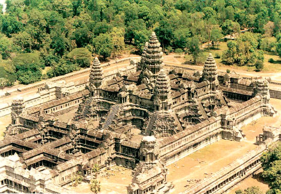
Temple of Angkor Wat. Notice the size of the people in the courtyards. (Source: http://gorillatales.com/KhmerTales/)
Khmer kings of the ninth century embarked on the building of the first Southeast Asian "water cities."
Indigenous ideas of the temple-mountain and urban waterways were fused with the monastic sangha and Indian temple architecture. The divine king created the metropolis as a national "heaven on earth."
Interestingly, one of the earlier types of this water plan that has been discovered is Nan Madol located in the middle of the Pacific Ocean in Micronesia. Like Angkor, Nan Madol was crisscrossed by a grid of interlocking canals.
Khmer city planning had a strong impact on Southeast Asia as a whole, but especially on the mainland. Homes and buildings were perched near or on the water. City designers strived for an harmonious blending of artifical and natural features.
Siam and Burma in particular followed the Khmer model adding their own innovations.

Ruins of Pagan, Myanmar. (Source: http://www.buddhistnews.tv/)

A 1740 map of Ayutthaya in Thailand. The superimposed triangles show temple locations both within the map region and in nearby areas. (Source: www.gisc.berkeley.edu/projects/ayutthaya.htm)

17th century painting of water parade at Ayutthaya. Source: http://escati.com/)
Regards,
Paul Kekai Manansala
Sacramento
References
Christie, Jan Wisseman. "States without Cities: Demographic Trends in Early Java, Indonesia," Indonesia 52 (October 1991), 23-40.
O'Connor, Richard A . A theory of indigenous Southeast Asian urbanism, Singapore : Institute of Southeast Asian Studies, 1983.
Reid, A.J.S. "The Structure of Cities in Southeast Asia, Fifteenth to Seventeenth Centuries," Journal of Southeast Asian Studies, 11,2 (1980): 235-50.
Ts'ui-Jung Liu, James et al. Asian Population History, Oxford University Press, 2001.
Wheatley, Paul. Nagara and commandery: Origins of the Southeast Asian urban traditions, Chicago: The University of Chicago, 1983.


0 comments:
Post a Comment